Land Surveys is Australia’s largest privately owned survey business, with over 300 professional land surveyors and staff across multiple office locations in Australia and Papua New Guinea. The company specialises in aerial, engineering and hydrographic surveys, land development, laser scanning, mining services and spatial data management.
Customer Story
How Land Surveys saved over $150,000 a year by improving remote survey data management
Land Surveys needed a more reliable way to manage large survey datasets across dispersed teams working between the office, home and remote Pilbara field locations. By implementing 12d Synergy, the business improved real-time access to current data, strengthened version control and reduced operational loss from double entry and downtime. The result was more than $150,000 in annual savings and approximately 99% uptime on project data.
The Challenge
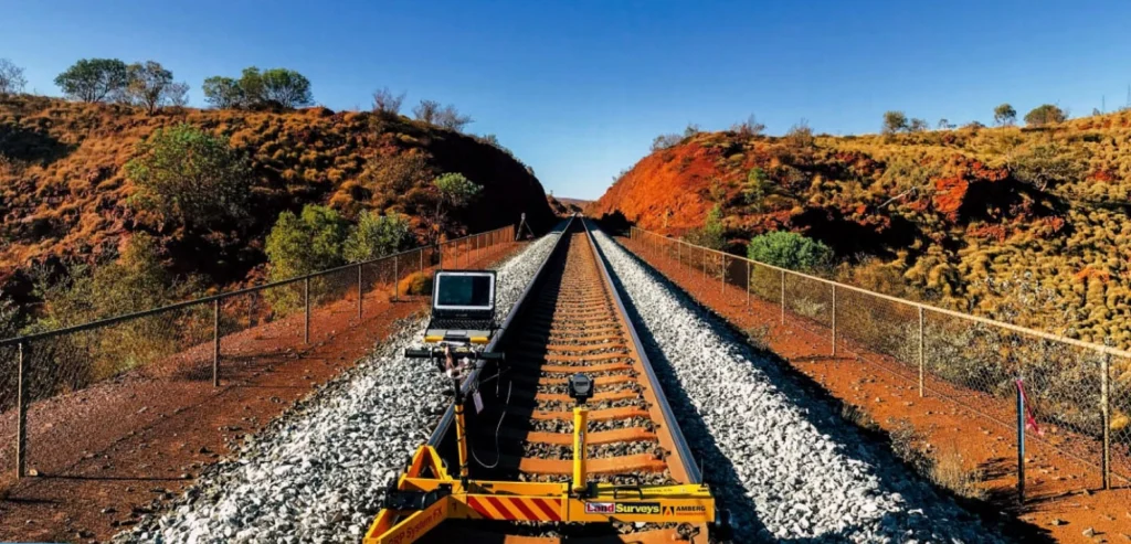
When Rio Tinto engaged Land Surveys on a $30 million rail camp upgrade project in the remote Pilbara region of Western Australia, the team was spread across a head office in Perth, another office in Karratha, a home office in Adelaide and on-site locations in the Pilbara, creating significant risk around access, coordination and communication. Mark Harris, Senior Surveyor, described the reality simply: with thousands of kilometres between team members, there was a lot of room for things to go wrong.
Before 12d Synergy, project files were managed in a network drive and shared through portable hard drives, OneDrive, Dropbox and Microsoft SharePoint. In remote conditions and with poor internet connections, this led to slow transfers, data corruption risks, weak collaboration and limited visibility over who had changed files and when. Mark Harris called poor data management “one of the greatest risks any surveyor faces on a project.”
The Solutions
After investigating options for over a year, Land Surveys selected 12d Synergy because of its customisable platform, flexibility for a diverse survey business, 12d Model integration and the team’s prior familiarity with the system. The rollout began gradually on a state-by-state basis using on-premises servers, before the business later re-evaluated its IT environment and migrated to a cloud-based hosting model.
12d Synergy gave Land Surveys a centralised environment for managing survey data, project files, correspondence and publishing workflows. Intelligent Data Transfers improved access speeds by transferring only changed files rather than the full project. Managed Folders, full audit history and check-in/check-out gave the team stronger traceability, rollback capability and a clearer single source of truth. The business also used personalised job templates, automated tasks and controlled issuing workflows to standardise processes and reduce system administration.
The Result
- Saved around $50,000 per year by reducing double entry of data
- Saved a further $100,000 per year by limiting system downtime.
- Maintained approximately 99% uptime on project data.
- Expanded enterprise deployment to around 400 users across the business.
- Improved field and office collaboration even with internet speeds of around 2–5 Mbps in remote areas.
- Reduced the risk of rework and redesign caused by outdated or superseded project data.
“The overarching positives of 12d Synergy have been that we are able to access data in real time. There’s no waiting to pull data off a USB or external hard drive when you’re out on site.”

Senior Surveyor, Land Surveys
Mark Harris
Final Thoughts
A remote survey business needed stronger data control
For Land Surveys, the challenge was not just moving files. It was maintaining confidence that remote staff, on site teams and office teams were all working from current and controlled information. When that confidence breaks down, survey errors, rework and redesign quickly become real commercial risks.
That made this case study about more than collaboration alone. It became a broader shift toward better information management, stronger traceability and a more resilient operating environment for remote project delivery.
Spotlight Project: Rio Tinto Rail Camp Upgrade, Pilbara
The Rio Tinto rail camp upgrade in the remote Pilbara was a clear example of why Land Surveys needed a more robust data management strategy. With team members spread across Perth, Karratha, Adelaide and on-site desert locations, the project exposed the limitations of generic file-sharing tools in a remote survey environment.
12d Synergy gave the team a more dependable way to share current data between field and office, helping reduce the risk of corruption, improve continuity and support coordination across long distances and unreliable internet conditions.
Improving field and office access in real time
One of the clearest benefits for Land Surveys was real-time accessibility. Mark Harris noted there was no longer any waiting to pull data from USBs or external hard drives, and if a design or calculation file needed review, colleagues in a central office could access it immediately rather than hoping a large email attachment would get through.
He also described the experience as seamless, noting that he could work from home in Adelaide on R&R while collaborating with teams on site in Pilbara, as well as with offices in Perth and Karratha and external engineers, even when site internet speeds were only around 2–5 Mbps.
Strengthening version control, QA and publishing workflows
Before 12d Synergy, Land Surveys had limited visibility over who had accessed or updated data and when. That was one of the business’s biggest risks, because staff could unknowingly work from superseded revisions and introduce errors into the field.
With Managed Folders, check-in/check-out and full audit history, the business gained much stronger control over versioning and QA. Mark Harris specifically called out the value of controlled issuing and transmittals, which replaced emailed zip folders with a more professional, time-stamped and branded process that clients responded well to.
Positioned for more profitable remote project delivery
For Land Surveys, 12d Synergy became more than a way to share files. It provided a more structured and scalable environment for managing data across remote survey operations, reducing business risk while improving speed, visibility and uptime.
By combining real-time access, stronger governance and measurable financial impact, the platform helped Land Surveys save over $150,000 per year and build a more reliable foundation for remote collaboration across major survey projects.